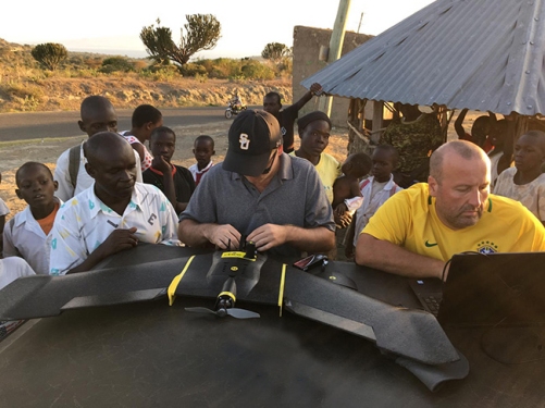
Mapping Fish Cages in Africa
Lake Victoria, the largest lake in the tropics, has a storied history that includes major shifts in ecology in recent years due to diverse anthropogenic impacts. Among these impacts has been the recent and rapid expansion of cage aquaculture of Nile tilapia in the lake. As part of an effort to assess the ecological consequences of this new industry, Unmanned Aerial Systems (UAS), very high-resolution satellite imagery, and geographic information systems (GIS) were used to map the tilapia fish cages in the Kenya portion of Lake Victoria, Africa. The data are useful in designing better systems for management of the Kenyan nearshore environment, particularly the status of local ecosystems and species, including the hundreds of threatened and endangered haplochromine cichlids. Understanding the impact of a significant intervention such as large-scale cage aquaculture requires a systems view, and UAS plus satellite data provide the spatial context and change detection capabilities required. Such a synthesis of UAS, very high-resolution satellite imagery, and GIS has allowed for accurate and rapid mapping of inshore tilapia fish cages with high positional accuracy. The significance of these observations lay in the speed with which cage aquaculture has grown in Lake Victoria. There were few or no floating cages as recently as 2012, but by 2018, the Kenyan portion of Lake Victoria was found to contain 4,357 fish cages covering 62,132 m2. The fish cages were organized within 534 fish farms covering 190,248 m2, and in fourteen aquaculture dominated regions covering just over 1 km2.
Partner - Kenya Marine Fisheries, Kisumu Center
CGMFC-21 - Continuous Global Mangrove Forest Cover for the 21st Century
CGMFC-21 was developed to allow for high-resolution global mangrove loss trends to be extracted on an annual basis. This need has been identified by the mangrove community for some time with the only other global mangrove database (non-temporal) representing data from the late 1990s. The indicator measures mangrove forest cover on many differing scales. It addresses policy questions related to mangrove cover and is a component of addressing wider forest trends.
Partner - UN Environment World Conservation Monitoring Centre in Cambridge
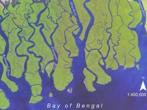
Hamilton, S. E., and D. Casey. 2016. Creation of a high spatio-temporal resolution global database of continuous mangrove forest cover for the 21st century (CGMFC-21). Global Ecology and Biogeography 25 (6):729-738. https://doi.org/10.1111/geb.12449